A good abandoned place does something weird to your brain. You see a cracked wall or empty window, and suddenly you are not just traveling.
You are investigating.
That is the pull of this New Mexico road trip. It follows places where the past still feels close enough to touch, even when the people are long gone.
Old forts and rail sites give the drive a mood you cannot fake when the desert takes over.
I built the route for anyone who loves stopping for the odd thing on the side of the road. The place that makes the car go quiet.
The spot where everyone gets out and starts taking photos before saying much.
Bring water and curiosity. Give yourself space between stops, because some places need a minute.
This is not about perfect views. It is about finding the stories that stayed behind after everything else moved on.
Mexican Canyon Trestle
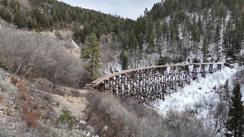
Few structures in New Mexico stop you in your tracks quite like the Mexican Canyon Trestle, rising above a pine-covered canyon just outside Cloudcroft on US-82.
Built in 1899 to carry the El Paso and Northeastern Railway through the Sacramento Mountains, this curved wooden trestle is a quiet marvel of early engineering.
I pulled over on a cool morning and stood at the edge of the canyon, looking up at the curved wooden frame arching overhead like something from a dream.
The trestle is no longer in active use, but it has been preserved and is accessible for visitors who want a close look at its intricate construction.
Cloudcroft itself sits at a refreshing elevation, making it a welcome stop in summer when the lowlands bake under the New Mexico sun.
The surrounding Lincoln National Forest adds a lush backdrop that feels almost out of place in a state better known for its desert landscapes.
Hiking trails near the trestle let you explore the canyon from multiple angles, and the views keep changing with every step.
If you have ever driven through southern New Mexico and wondered what history hides in the mountains, this trestle answers that question with grace and a little bit of wonder.
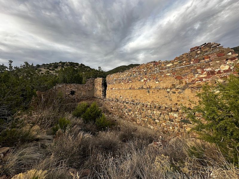
Lake Valley Historic Townsite
Lake Valley Historic Townsite feels like the kind of place where the desert kept the last chapter. Once a silver mining boomtown, it rose fast after rich deposits drew people, money, and big expectations into this quiet stretch near Hillsboro.
Then the boom faded, the crowds moved on, and the town slowly became one of southern New Mexico’s most memorable ghost town stops. Today, it is not just a quick roadside glance.
You can still see the restored schoolhouse, the chapel, old building remains, weathered streets, and wide-open views that make the silence feel heavier.
It is easy to imagine wagons, miners, families, arguments, church bells, and school lessons filling the same ground that now sits still under the sun. That is what makes Lake Valley such a strong replacement for Percha Creek Bridge.
It gives readers more story, more atmosphere, and far more photo options. The stop feels lonely, but not empty.
Every wall and doorway seems to be holding onto something. Bring water, wear decent shoes, and take your time.
This is the kind of place that rewards people who wander slowly and look twice before heading back to the car.
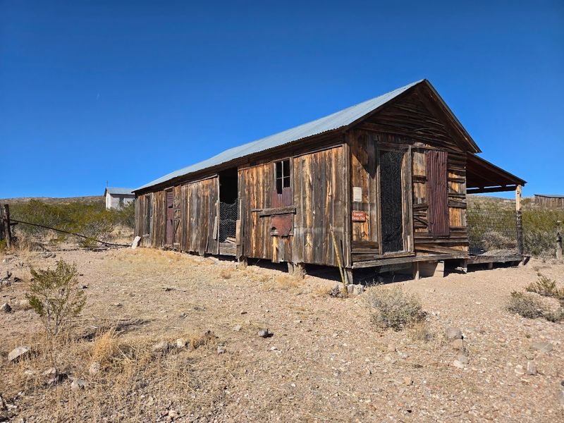
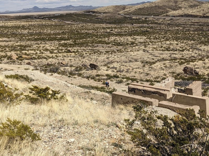
Kelly Mine / Kelly Ghost Town
Kelly Road SE outside Magdalena leads to one of New Mexico’s most atmospheric ghost towns, a place where the silence is thick enough to feel like a presence.
Kelly Mine and its surrounding ghost town once hummed with the energy of lead, zinc, and silver extraction, drawing workers and families to this remote stretch of the Magdalena Mountains.
Today, the ruins of stone buildings, collapsed headframes, and rusted machinery paint a vivid picture of boom-and-bust life in the American Southwest.
I wandered through the remnants of what was once a thriving community and found myself reading the landscape like a map of ambition and eventual abandonment.
The Magdalena area has a wonderfully rugged personality, with wide skies and open range that feel unchanged from the mining era.
Kelly Ghost Town is managed with care, and visitors are welcome to explore on foot, though the terrain is uneven and sturdy shoes are a smart choice.
The mine shafts and structural ruins are off-limits for safety reasons, but the accessible areas offer plenty of photographic and historical interest.
Standing among those stone walls with the wind cutting across the hillside, I understood exactly why ghost town enthusiasts rank Kelly among the most rewarding stops in the entire Southwest.
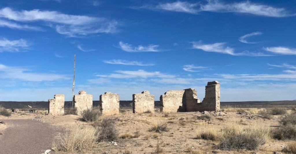
Fort Craig Historic Site
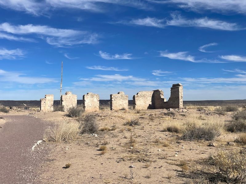
Old US Highway 85 near San Antonio, New Mexico, leads to the crumbling adobe remains of Fort Craig, a post that once played a pivotal role in the Civil War battles of the Southwest.
The fort was established in the mid-1800s and served as a key defensive position along the Rio Grande, protecting the region during a period of intense conflict and territorial tension.
Walking through the site today, you navigate a landscape of low adobe walls, eroded earthworks, and open desert that stretches in every direction without interruption.
There are no crowds here, no gift shops, and no guided tours on most days, which gives the experience a raw, unscripted quality that polished tourist sites simply cannot replicate.
The Bureau of Land Management maintains the area and provides interpretive signs that help fill in the historical context as you move from one crumbling structure to the next.
Fort Craig sits in the Jornada del Muerto desert basin, a name that reflects just how unforgiving this landscape was for soldiers stationed here.
The isolation of the site is part of its power, and the silence feels earned rather than empty.
Visiting Fort Craig reminded me of exploring forgotten Civil War sites elsewhere in the South, where history sits close to the surface and speaks without needing to raise its voice.
Fort Bayard Historic District
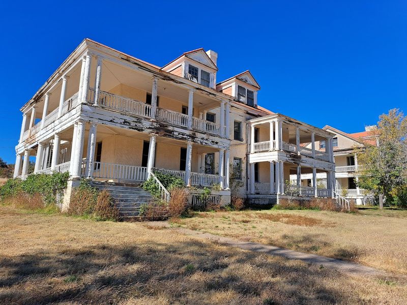
At 11990 US Highway 180 near Santa Clara, Fort Bayard stands as one of New Mexico’s most layered historic sites, having served as a military post, a tuberculosis sanatorium, and eventually a state-run medical facility before falling into partial disuse.
The fort was established after the Civil War and is closely associated with the Buffalo Soldiers, the African American cavalry regiments who patrolled the Southwest during the Indian Wars era.
Many of the original brick buildings still stand, giving the district a surprisingly intact feel compared to other frontier-era military sites that have faded to rubble.
I spent a long afternoon walking the grounds, studying the architecture and imagining the range of lives that passed through this single location across more than a century.
The Grant County area surrounding Santa Clara is rich with mining history and natural beauty, making Fort Bayard a natural anchor for a longer regional exploration.
The Gila National Forest sits nearby, and the combination of historical depth and outdoor access makes this stop particularly satisfying for travelers who like variety.
Preservation efforts have kept several structures in reasonable condition, though the site still carries the faded grandeur of a place that outlived its original purpose.
Fort Bayard is the kind of stop that earns a longer visit than you planned, and you will leave with more questions than you arrived with.
Steins Railroad Ghost Town
Steins Road in Roadforks, New Mexico, leads to one of the most intact and eerie ghost towns in the entire Southwest, a place where the buildings still stand but the people are long gone.
Steins grew up around the Southern Pacific Railroad in the late 1800s and served as a water stop and supply point for trains crossing the Peloncillo Mountains.
When the railroad shifted operations and the nearby mines played out, the town emptied quickly, leaving behind a remarkably preserved collection of adobe and wood-frame structures.
From outside the gated property, you can still see the dusty remains of old storefronts, adobe structures, and weathered buildings that hint at the town’s railroad past.
The personal artifacts and preserved buildings are what set Steins apart from other ghost towns, because the human story feels immediate rather than distant.
The site is privately owned and is not generally open to the public, so visitors should check current access before making the trip and view the ruins respectfully from permitted areas.
Steins sits right off Interstate 10 near the Arizona border, making it an easy add-on for anyone driving across southern New Mexico.
The Peloncillo Mountains frame the town on one side, and the open Chihuahuan Desert spreads out on the other, creating a backdrop that is stark and beautiful in equal measure.
Dripping Springs Natural Area
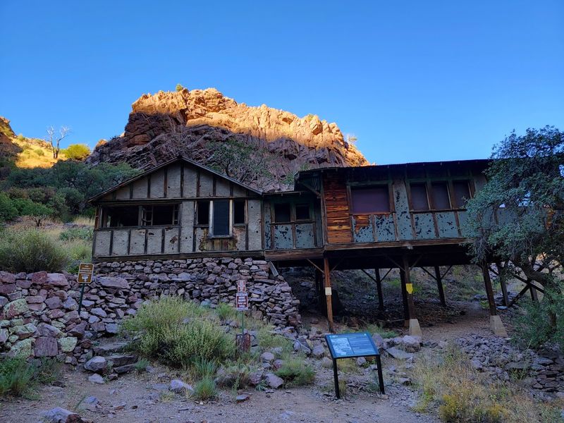
At 15000 Dripping Springs Road in Las Cruces, the Organ Mountains rise sharply from the desert floor and cradle a set of ruins that most visitors to the area never expect to find.
Dripping Springs Natural Area holds the remnants of a 19th-century resort and a later sanitarium, both built to take advantage of the mountain springs and cool canyon air.
The Van Patten Mountain Camp operated here as a retreat for travelers seeking rest and scenery, and the stone foundations and walls that remain give a clear sense of the original ambition.
I hiked the well-maintained trail from the visitor center to the ruins on a bright winter morning, and the contrast between the warm sunlight and the cold canyon shade kept the walk interesting throughout.
The Bureau of Land Management oversees this area, and the trail system is clearly marked and accessible for most fitness levels.
Wildlife sightings are common along the route, and I spotted a roadrunner darting between boulders before I even reached the ruins.
The Organ Mountains themselves are a dramatic constant throughout the hike, their jagged peaks providing a backdrop that shifts in color and texture as the light changes.
Dripping Springs is proof that New Mexico’s abandoned history does not always hide in remote corners; sometimes it waits just a short drive from a major city.
Organ Ghost Town
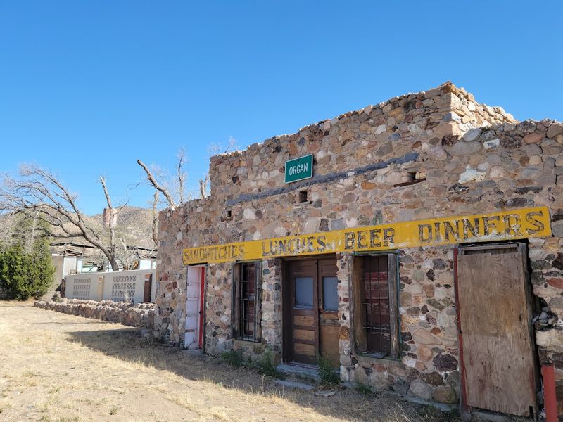
Just off US Highway 70 in the small community of Organ, New Mexico, the remnants of a once-active mining settlement sit in the shadow of the jagged Organ Mountains.
Organ was established as a lead and silver mining camp in the 1800s, and at its height it supported a population of miners, merchants, and families drawn by the promise of precious metals.
The town declined as ore deposits thinned and transportation options improved, pulling residents toward larger centers like nearby Las Cruces.
What remains today is a scattered collection of adobe walls, collapsed structures, and a handful of occupied properties that blur the line between ghost town and living community.
I found the site quietly absorbing, partly because it lacks the dramatic presentation of a preserved tourist attraction and instead just exists, unpolished and honest.
The Organ Mountains loom so close here that they feel almost theatrical, their rocky spires catching the light in ways that shift from orange to purple as the afternoon wears on.
Visitors should be respectful of private property, as some structures in the area are still inhabited or owned.
Organ pairs naturally with a stop at Dripping Springs Natural Area just up the road, making this stretch of US-70 a productive and visually striking section of any New Mexico road trip.
Cuervo
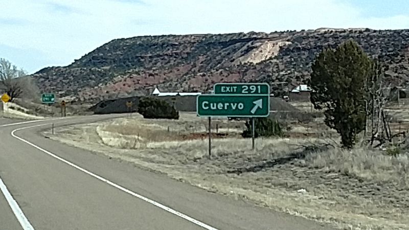
Interstate 40 cuts through some of the flattest and most hypnotic terrain in New Mexico, and Cuervo appears along that ribbon of highway like a rumor that turned out to be true.
This tiny community in Guadalupe County once served travelers on old Route 66, offering fuel, food, and a place to rest before the next long stretch of open road.
When the interstate bypassed the original route, Cuervo’s commercial reason for existing evaporated almost overnight, and the town began its long, slow return to the desert.
Today, the abandoned church, collapsed storefronts, and weathered houses along Cuervo’s short main street stand as a textbook example of how infrastructure decisions can reshape entire communities.
I pulled off the highway and walked through the site on a windy afternoon, with tumbleweeds skipping past and the only sound being the distant hum of traffic on I-40.
The visual contrast between the ruin and the active interstate just a short distance away is oddly moving, a reminder of how quickly a place can go from essential to invisible.
Photographers love Cuervo for its unobstructed light and weathered textures, and the flat terrain means you can compose wide shots without much effort.
Road trip lovers who have chased old Route 66 through Arkansas and Oklahoma will feel a familiar ache standing in Cuervo, because the story it tells is universal.
Albuquerque Rail Yards
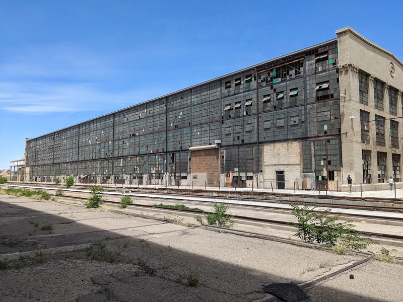
At 777 1st Street SW in Albuquerque, the Rail Yards sit on the southern edge of downtown like a sleeping giant that the city has not quite decided what to do with yet.
Built in the early 1900s as a repair and maintenance facility for the Atchison, Topeka and Santa Fe Railway, this complex once employed hundreds of workers and kept the Southwest’s rail network running.
The sheer scale of the place is the first thing that hits you: vast machine shops, towering brick facades, and cavernous interior spaces that swallow sound and light in equal measure.
I visited during one of the periodic public open house events the city hosts, and the experience of walking those enormous floors felt closer to exploring a cathedral than a rail yard.
Efforts to redevelop the site have been ongoing for years, with community groups and city planners debating the best way to honor the history while creating new uses for the space.
The Rail Yards Market, held on weekends in warmer months, brings local vendors and musicians into the complex and gives visitors a lively way to experience the space.
Albuquerque’s broader rail district neighborhood adds context, with murals and public art reflecting the working-class history of the area.
Much like revitalized rail districts found across the South, the Albuquerque Rail Yards show how industrial ruins can become community anchors when given the right attention.