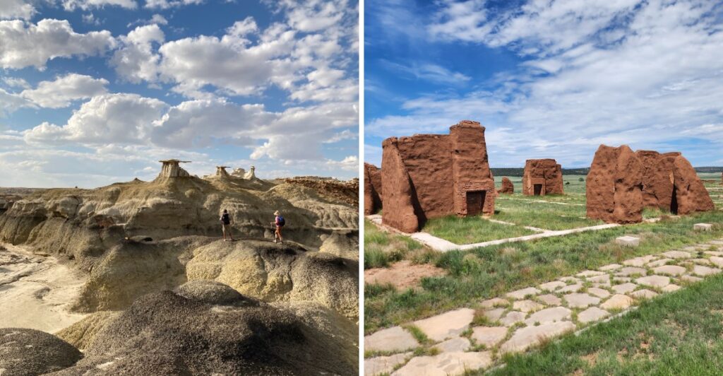
You do not need a packed tourist district to make a fall drive memorable. Sometimes the best part is turning onto a quieter road and realizing the landscape just changed completely.
Cooler days bring a good excuse to explore farther, especially once desert trails become easier to tackle. New Mexico has rock formations that look sculpted by hand, along with ancient sites that still carry traces of the people who lived and traveled there.
One stop puts thousands of petroglyphs beside a rugged trail. Another lets you drive toward the rim of a volcano.
Farther down the road, black lava fields stretch across the basin while migratory birds gather near the Rio Grande. The mix keeps things interesting without making the trip feel repetitive.
Some places need reservations, and others require a rougher drive. Check conditions and pack water.
Give yourself enough time to stop when the view demands it.
1. Kasha-Katuwe Tent Rocks National Monument
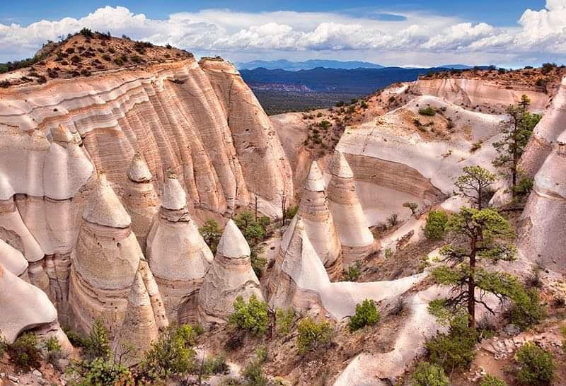
Cone-shaped rock towers stand in rows here like a canvas village that never got packed up. The name means white cliffs in the Keresan language, and the formations came from volcanic eruptions that buried the area in thick layers of pumice, ash, and tuff.
Erosion did the sculpting work over an unimaginable stretch of time. The monument sits along Indian Service Route 22 in Cochiti Pueblo, New Mexico, and it is co-managed with the Pueblo de Cochiti, who hold deep cultural and spiritual ties to this land.
Two trails do most of the heavy lifting. The Cave Loop Trail runs an easy 1.2 miles and works well for birdwatching or just staring at rock.
The Canyon Trail stretches 1.5 miles one way, squeezing through a narrow slot canyon before a steep climb to the mesa top.
Once you reach the top, the Sangre de Cristo, Jemez, and Sandia ranges spread out with the Rio Grande Valley below. Honestly, the whole place looks borrowed from another planet.
Reservations and tribal access passes are required, so plan ahead rather than showing up hopeful. Foot travel only keeps the canyon quiet, which is exactly how it should feel.
2. El Morro National Monument
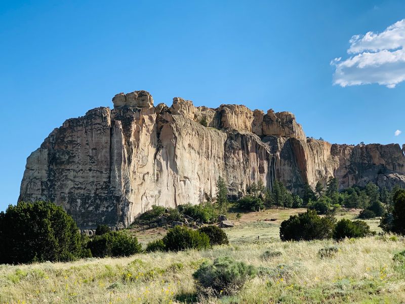
Travelers crossing this dry stretch of country once aimed straight for a single reliable waterhole, and it still sits at the base of a towering sandstone bluff. El Morro, meaning the headland, rises along Ramah NM-53 in Ramah, New Mexico.
More than 2,000 inscriptions and petroglyphs cover the cliff face. Ancestral Puebloans carved images first, then Spanish explorers added flourishing signatures, and later American pioneers scratched their own names and dates into the same rock.
Reading that stone wall feels like flipping through a guest book kept for centuries. The layered handwriting of so many different people is quietly humbling.
The Inscription Trail covers 0.75 miles, leading past hundreds of carvings and the permanent pool that made this spot matter. For more, the two-mile Headland Trail climbs to the top of the bluff, where wide views open up and the partially excavated Ancestral Puebloan village of Atsinna waits.
A 15-minute video at the visitor center covers the natural and cultural background, which helps everything on the trail make sense. Fall brings cooler air and better light for photographing the shaded cliff face, where the carvings show up sharper than they do under harsh midday sun.
3. Bisti/De-Na-Zin Wilderness
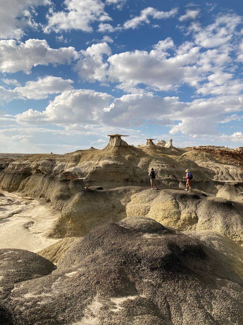
Forget marked trails. Out here, off County Road 7297 near Bloomfield, New Mexico, you navigate by landmark, instinct, and whatever GPS coordinates you loaded before the signal vanished.
The Bisti/De-Na-Zin Wilderness covers roughly 45,000 acres of shale hills managed by the Bureau of Land Management. Bisti means large area of shale hills in Navajo, while De-Na-Zin translates to standing cranes, a nod to petroglyphs found within the area.
Hoodoos, pinnacles, desert spires, and arches turn the terrain into a rock gallery nobody curated. Colors shift from gray shale to pale sandstone, and petrified wood shows up scattered across the clay.
Paleontological resources are protected here too, so looking beats collecting.
Hiking means crossing clay hills and sandstone outcrops on your own route, which makes even short distances feel like real expeditions. Fall and spring bring the most comfortable conditions, since summer heat is brutal and winter turns cold.
Primitive dispersed camping is allowed, with no fees and no facilities whatsoever. Cell service ranges from minimal to nonexistent, which some people consider the whole point.
Bring extra water, a paper map, and sturdy boots. The solitude out here is the kind that stays with you afterward.
4. Three Rivers Petroglyph Site
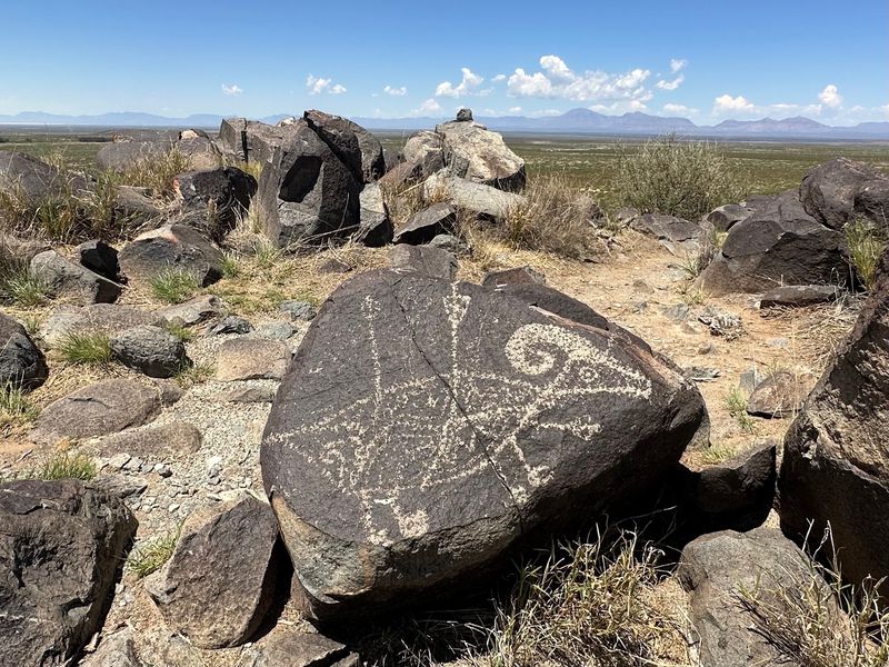
Over 21,000 carvings cover a single basaltic ridge at 455 3 Rivers Rd in Tularosa, New Mexico. That makes this one of the largest concentrations of rock art anywhere in the Southwest.
The Jornada Mogollon people created these images across a long span of centuries. Masks, sunbursts, wildlife, handprints, geometric patterns, corn, and clouds all appear, offering glimpses into how they saw their world and their spiritual life.
Their technique was straightforward and effective. Stone tools chipped away the dark patina coating the rock, revealing lighter stone underneath, and those designs have held up remarkably well.
A rugged half-mile Petroglyph Trail runs along the ridge and puts you right beside many of the best carvings. Wear shoes with decent grip, because the footing is uneven basalt rather than smooth pavement.
A second short trail leads to the remains of a Mogollon village, the likely home of the artists themselves. Partial excavation uncovered foundations of prehistoric buildings, and the community occupied the spot for roughly four centuries.
Cooler autumn temperatures make the walk far more pleasant than a summer attempt. Standing among thousands of images feels like a conversation happening entirely without words.
5. Valley of Fires Recreation Area
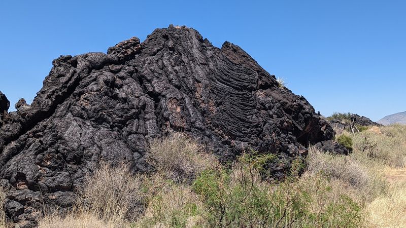
Black rock stretches across the Tularosa Basin at 6158 US-380 in Carrizozo, New Mexico, and it looks like it cooled last week. The Carrizozo Malpais counts among the youngest lava flows in the continental United States.
Originating from a shield volcano, the flow spread roughly 44 miles across the basin floor. The result is a stark, dark, endlessly textured landscape unlike anything else in the region.
Interpretive trails wind across ropy pahoehoe lava, letting you see the folds and ridges up close. What surprises most people is the life crowding into every crack: plants taking root, lizards darting, birds calling from unexpected places.
Contrast is the real attraction. Dark volcanic rock against a brilliant desert sky turns almost theatrical near sunrise and sunset, which is when photographers tend to appear.
Camping and picnicking are both available on site, so a quick stop can easily stretch into an overnight. Sites perched above the flow give you a front-row view of the black expanse below.
Fall temperatures help enormously, since the dark rock soaks up heat and radiates it back. The scale of this flow really does make you respect what the earth can do.
6. City of Rocks State Park
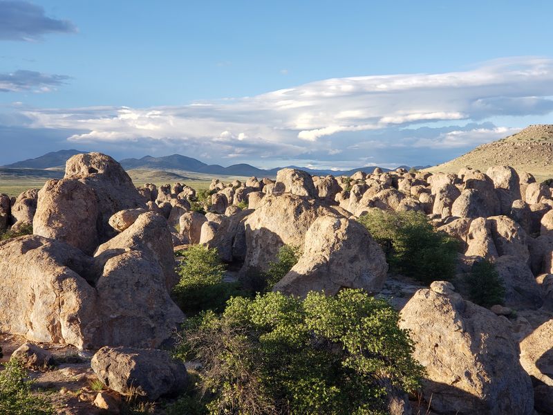
Stone columns rise up to 40 feet high and stand in clusters divided by natural streets and avenues. Walking between them at City of Rocks State Park, located at 327 NM-61 in Faywood, feels like wandering a rock neighborhood.
Volcanic ash laid the foundation long ago, and erosion carved the pinnacles across millions of years. Formations like these exist in only a handful of other places worldwide, which makes this one-square-mile patch of Chihuahuan desert unusually special.
Activities cover plenty of ground. Hiking trails thread through the formations, mountain biking is popular, and wildlife viewing plus birding reward anyone who slows down and watches.
A desert botanical garden introduces the local plants, useful if you cannot tell an ocotillo from a cholla. Nighttime brings the other headline attraction, since dark skies here are excellent and the park keeps a public observatory.
Campers get choices too. Developed sites include hookups, while dry camping spots tuck right in among the boulders for something far more private.
Autumn nights turn crisp and clear, which suits stargazing perfectly. Standing beneath these natural towers has a way of making a person feel pleasantly small.
7. Fort Union National Monument
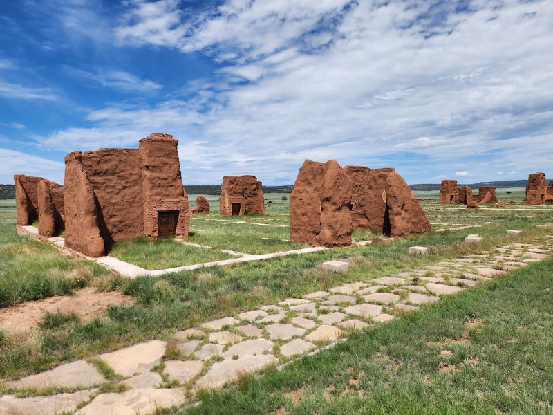
Chimneys stand alone on open prairie at 3115 NM-161 in Watrous, New Mexico, marking what was once the largest nineteenth-century military fort in the region. Adobe walls have softened over the decades, but the outlines remain clear.
For four decades, Fort Union served as a supply depot and guardian of the Santa Fe Trail. Soldiers stationed here protected settlers and wagon trains moving across an enormous stretch of territory.
Three successive forts rose on this ground as the Army’s needs changed. Each version tells part of the story of how the frontier shifted around it.
A self-guided trail loops through the ruins, past roofless rooms, weathered walls, and those persistent chimneys. Wagon wheel ruts from the Santa Fe Trail are still visible nearby, pressed into the earth by countless crossings.
The visitor center holds historical exhibits and a museum that fill in details about daily life, supply routes, and the fort’s role across New Mexico and the wider Southwest. Picturing families living out here, so far from everything, sticks with you.
Fall winds sweep the grasslands and the light goes golden late in the day. Few places make the frontier feel this close.
8. Salinas Pueblo Missions National Monument, Gran Quivira Unit
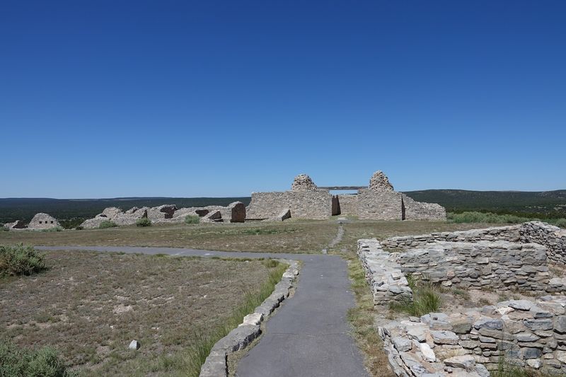
Massive stone walls rise from grassland at 4030 Quivera Flats Road in Mountainair, New Mexico. They belong to San Buenaventura, a mission church that was never finished.
Gran Quivira forms one unit of Salinas Pueblo Missions National Monument, which preserves ruins of ancient Pueblo villages alongside seventeenth-century Spanish missions. This particular site was once a thriving Pueblo community before it became a significant mission outpost.
Walking among the substantial stone ruins gives you a sense of two worlds pressed together. The scale of construction out here, in such a remote spot, is honestly hard to wrap your head around.
The story is complicated rather than tidy. Exhibits at the visitor center cover Pueblo life long before European contact, the arrival and impact of Spanish colonizers, and the eventual abandonment of these settlements.
Trails through the site are short and manageable, making this an easy stop even for travelers short on time. Interpretive signs help connect the stone foundations to the people who built them.
Autumn brings comfortable walking weather and quiet mornings with hardly another car in the lot. Standing in those roofless rooms invites a long, thoughtful pause.
9. Cerrillos Hills State Park
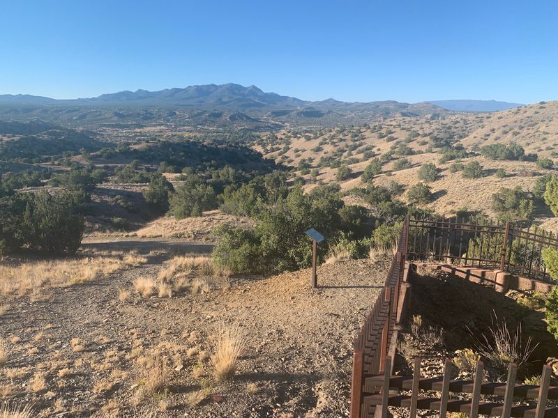
Turquoise drew people to these hills more than a thousand years ago, and the diggings are still there. Cerrillos Hills State Park sits at 44 Camino Turquesa in Los Cerrillos, New Mexico, just off the Turquoise Trail National Scenic Byway.
Ancestral Puebloans mined turquoise here starting around 900 AD. Later, Spanish prospectors came looking for gold, silver, and lead, and the hills supplied lead used for Pueblo pottery glazes across several centuries.
Five miles of trails wind through this mineral-rich terrain. Hiking, mountain biking, and horseback riding all work here, and interpretive plaques along the way explain what the old shafts and tailings represent.
Views are a serious bonus. The Sandia, Ortiz, Jemez, and Sangre de Cristo ranges all show up on the horizon, which keeps photographers busy on clear autumn afternoons.
The village of Cerrillos itself deserves a stop after your hike. Once a busy mining town, it holds onto an Old West look with dirt streets and independently owned shops.
Those stories of prospectors chasing fortune add real texture to an otherwise quiet walk. Cooler fall air makes the climb through the juniper noticeably easier.
10. Quebradas Backcountry Byway
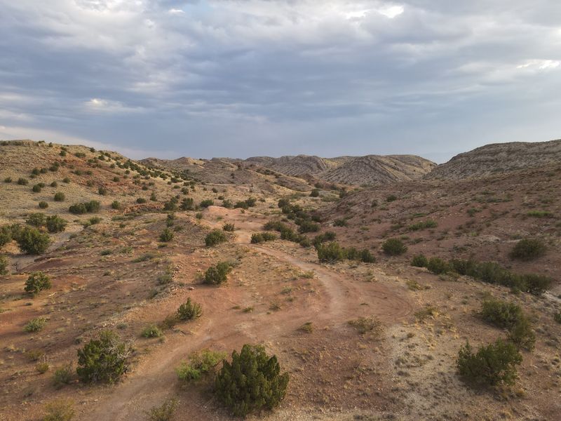
Twenty-four miles of unpaved county road east of Socorro, New Mexico, deliver one of the most colorful drives in the state. The Quebradas Backcountry Byway climbs over benchlands above the Rio Grande floodplain and cuts through rugged ridges.
Rock layers here practically show off. Alternating bands of red and yellow sandstone, red and purple shale, and white to gray limestone stack up along the roadside like someone arranged them on purpose.
Erosion carved standout spots including Arroyo de la Presilla and Arroyo del Tajo, where water-sculpted limestone and granite walls meet vivid badlands. Pull over often, because the scenery changes constantly.
Wildlife watching pays off along the way. Mule deer, coyotes, and bobcats live out here, and the bird list includes sandhill cranes and roadrunners scurrying across the track.
Practical matters count. A high-clearance vehicle is recommended, and heavy rain can make sections difficult or impassable because of flash flooding, so check conditions first.
No facilities exist along the route, meaning water, fuel, snacks, and a spare tire should ride along with you. Every mile reads like another page of geology turned by hand.
11. Bosque del Apache National Wildlife Refuge Visitor Center
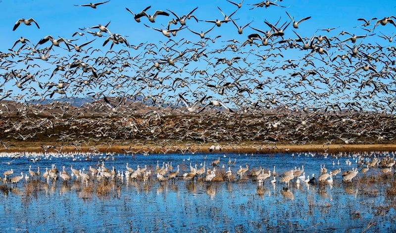
Thousands of wings lift off shallow ponds at sunrise, and the noise is unforgettable. The Bosque del Apache National Wildlife Refuge Visitor Center sits at 1001 NM-1 in San Antonio, New Mexico, tucked between the Chupadera Mountains and the San Pascual Mountains.
Established in 1939, this refuge covers roughly 57,331 acres and serves as a critical stopover for migrating waterfowl. That role has earned it recognition among birdwatchers worldwide.
Fall and winter bring the big show. Sandhill cranes, snow geese, Ross’s geese, and assorted ducks arrive in enormous numbers, filling the wetlands with motion and sound.
Mid-September through mid-November works beautifully, with migratory birds moving through and the first cranes and geese typically showing up around late October. Early morning and late afternoon offer the most activity.
Auto tour loops let you watch from the car, which doubles as an excellent bird blind. Hiking trails add closer looks for anyone willing to walk quietly.
Beyond the birds, mule deer, coyotes, and jackrabbits turn up regularly. Golden cottonwoods along the river make the whole refuge glow in autumn, and binoculars belong in your bag.
12. Capulin Volcano National Monument
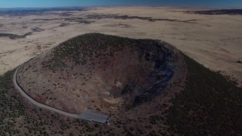
Driving up a volcano sounds like a tall tale, but a paved road spirals right to the rim at 46 Volcano Highway in Capulin, New Mexico. A parking lot waits at the summit, which makes this one of the most accessible volcanic experiences anywhere.
The cinder cone belongs to the larger Raton-Clayton Volcanic Field and has stayed remarkably well preserved. Its shape is so clean it looks almost drawn.
From the rim, a one-mile loop trail circles the crater and hands over 360-degree views. On clear days you can see into parts of Texas, Oklahoma, and Colorado from a single vantage point.
Another trail drops straight into the bottom of the 415-foot-deep crater. Standing inside a volcano’s throat is a strange and genuinely memorable feeling.
Autumn adds cooler hiking temperatures and sharp, clear air that stretches the views even farther. Wind on the rim can be strong, so a jacket earns its space in the pack.
Night skies here rank among the darkest in the country, drawing stargazers who stay long after the sun drops. The forces that built this cone are worth pondering from the top.