New Mexico has a funny way of ruining your schedule in the best possible way. You tell yourself you are just driving through, then the sky turns gold, the road bends past a canyon, and suddenly you are pulling over like everyone else who thought they could keep moving.
I love drives like that. No rush.
No perfect plan. Just a road that keeps giving you reasons to slow down.
These backroads are made for curious travelers. You pass an old adobe church and wonder who last rang the bell.
You spot a quiet overlook and forget what time it is. The views do not shout for attention.
They simply show up, one mile at a time, and somehow stay with you.
If your next trip needs more story and less highway noise, this is where I would start. These scenic roads make the detour feel like the whole point.
1. Sandia Crest Highway
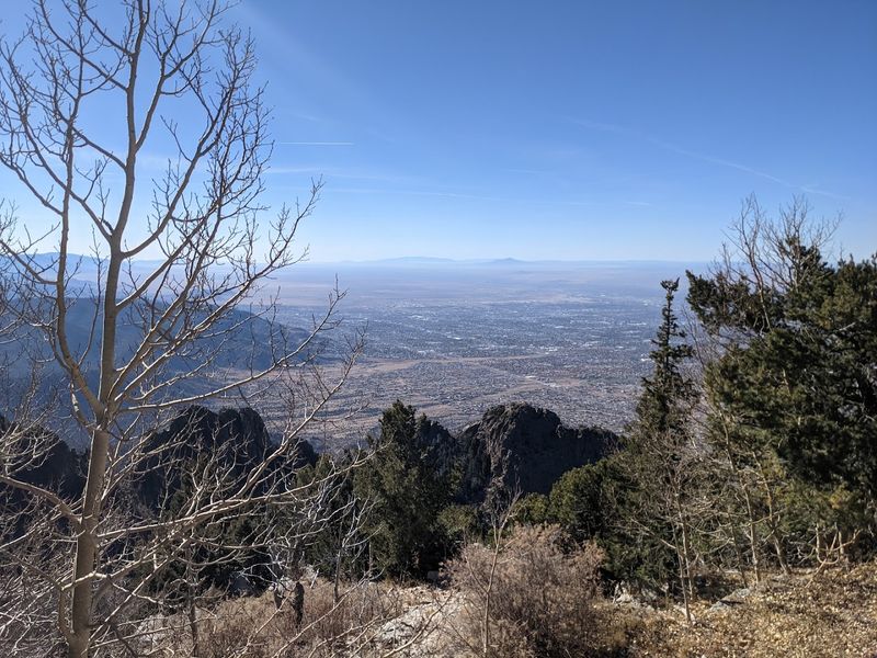
NM-536 West climbs through Cibola National Forest outside Sandia Park. The drive feels less like a commute and more like slowly unwrapping a gift that keeps getting better with every curve.
The Sandia Crest Highway begins just outside Sandia Park, NM 87059. It weaves through a dense forest of ponderosa pine and spruce before delivering you to one of the most jaw-dropping panoramic views in the entire Southwest.
On a clear day at the summit, you can see for what feels like forever, with the Rio Grande Valley stretching out far below and the Albuquerque city grid glittering like scattered coins.
I remember stopping at a small pullout halfway up and stepping out of the car. I just stood there in the cool mountain air, completely forgetting I had anywhere else to be.
The temperature drops noticeably as you gain elevation, so packing a light jacket is always a smart move even in summer.
Wildlife sightings are common here, and I have spotted mule deer grazing just a few feet from the road on more than one occasion.
The Crest Trail at the top offers a short but rewarding walk along the ridgeline for those who want to stretch their legs after the drive.
Fall brings a spectacular show of golden aspens mixed with the dark green conifers, making the road feel like it was designed specifically for photographers.
Winter can transform the whole experience into something quieter and more dramatic, with snow-dusted pines lining the road on both sides.
Before planning the full drive, check current road and forest access, since weather, maintenance, and closure orders can affect the route to the crest.
Sandia Crest Highway earns a permanent spot in your road trip highlight reel the first time you take it. Somehow, it still manages to top itself every time you return.
2. Turquoise Trail National Scenic Byway
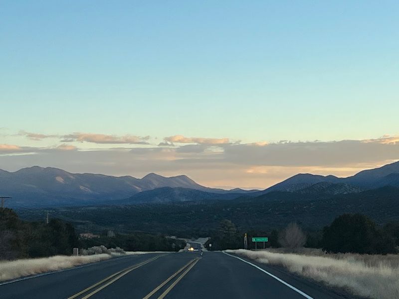
Highway 14 has a quiet kind of magic as it links Albuquerque and Santa Fe. Small towns along the way seem to exist in their own colorful universe.
The Turquoise Trail National Scenic Byway runs through the Sandia Park area. It rolls for about 50 to 62 miles through some of the most visually rich landscape in the state.
Golden, Madrid, and Cerrillos are the three historic mining towns strung along this route like beads on a necklace, each one with its own personality and its own reason to stop.
Madrid caught me completely off guard the first time I drove through. What used to be a coal mining town has reinvented itself as a hub for artists, musicians, and craftspeople, with galleries, handmade jewelry, and live weekend music filling the main strip.
Cerrillos is quieter and older-feeling, with dusty streets and adobe buildings that make you feel like you have stepped into a film set for a classic Western.
Golden sits at the southern end and offers a small but fascinating historic church that draws photographers and history lovers in equal measure.
The Sandia Mountains provide a dramatic backdrop for much of the drive, their rose-colored granite shifting through shades of pink and orange depending on the time of day.
I always recommend starting this drive in the morning so the light hits the mountains from the east and the towns are still waking up and unhurried.
Pack a small cooler and plan for at least one unscheduled stop. Keep your camera within arm’s reach because the Turquoise Trail rewards curious travelers at nearly every mile marker.
By the time Santa Fe appears on the horizon, you will already be thinking about how soon you can turn around and drive it again.
3. Jemez Historic Site
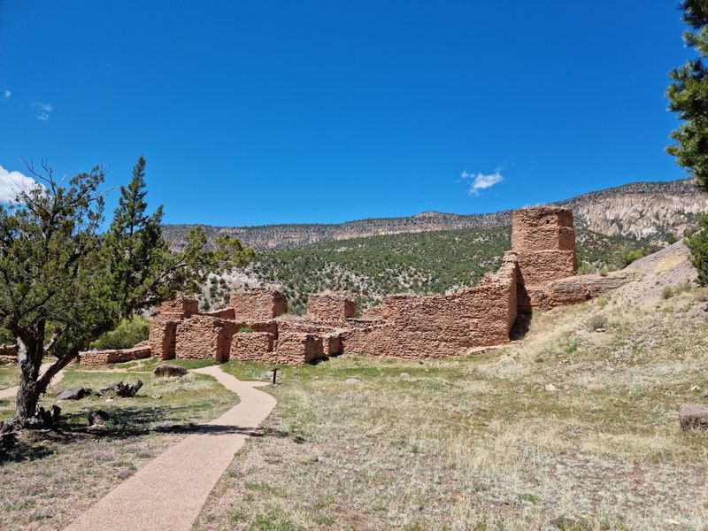
A stop off NM-4 in Jemez Springs brings you to Jemez Historic Site. At 18160 NM-4, Jemez Springs, NM 87025, the place feels like a pause button for the modern world.
The site preserves the ruins of Gisewa Pueblo, an ancient village built by the ancestors of the modern Jemez people. It also includes the 17th-century Spanish mission church of San Jose de los Jemez, whose massive stone walls still stand in quiet, weathered dignity.
The interpretive trail moves through a compact, peaceful space, but the history here feels anything but small.
The red canyon walls surrounding the ruins glow a deep terracotta in the afternoon light, creating a natural frame that makes every photograph look intentional and stunning.
The site is managed by New Mexico Historic Sites and offers a small but thoughtful museum that explains the layered cultural history of the Jemez Valley in accessible, engaging detail.
Jemez Springs itself is a charming village worth exploring before or after your visit, with hot spring bathhouses, a bakery, and a handful of shops tucked along the main road.
The drive along NM-4 leading to the site passes through a breathtaking red rock canyon carved by the Jemez River, and honestly the road itself deserves its own slow, appreciative drive.
Spring and fall are the best seasons to visit, when the temperatures are comfortable and the canyon colors are at their most vivid.
Children and adults alike tend to linger longer than expected here, drawn in by the scale of the ruins and the quiet power of the place.
The Jemez Historic Site is one of those spots that stays with you long after the drive home, quietly reminding you how deep and layered this land really is.
4. Valles Caldera National Preserve
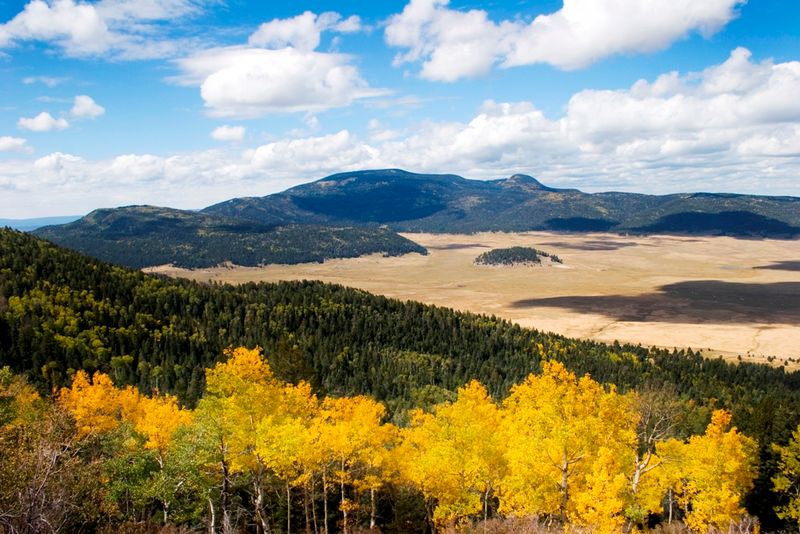
Few places in New Mexico stop a road tripper in their tracks like the first glimpse of Valles Caldera National Preserve. A huge volcanic caldera opens into one of the most serene and sweeping landscapes I have ever seen from a car window.
Located at 090 Villa Louis Martin Dr, Jemez Springs, NM 87025, this stunning preserve sits within the remnants of a supervolcano that erupted long ago and left behind a wide, grassy caldera bowl ringed by forested ridges.
The scale of the valley floor is hard to fully absorb at first because it is simply enormous, and elk herds often roam through the meadows in the early morning and evening hours, completely indifferent to the cars slowing down to watch them.
I visited on a crisp October morning and the golden grasses covering the caldera floor were practically glowing against the dark green of the surrounding pines.
The preserve offers hiking, cross-country skiing, fly fishing, and ranger-led programs throughout the year, so there is always a reason to stop rather than just drive through.
NM-4, the road that passes through the preserve, is one of the most scenic stretches of pavement in the entire state, and the caldera viewpoint pullouts are generously placed for exactly the kind of lingering that this landscape demands.
History buffs will appreciate knowing that this land has a rich ranching past and was privately owned for much of the 20th century before becoming a national preserve in 2000.
Sunrise and sunset paint the caldera in colors that shift from pale gold to deep amber. Photographers who time their visit to catch that light often leave with images they end up printing large and hanging on walls.
Valles Caldera is the kind of place that quietly resets your perspective on what open space can feel like when it is truly protected and truly wild.
5. Gila Cliff Dwellings National Monument
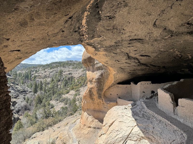
The road to Gila Cliff Dwellings National Monument at 26 Jim Bradford Trail, Mimbres, NM 88049 requires commitment. The drive through the remote mountains of southern New Mexico is long, winding, and wonderfully far from anything resembling a traffic jam.
That remoteness is honestly part of the reward, because by the time you arrive, you feel like you have genuinely earned the view of those ancient stone rooms tucked into natural cave alcoves high above the canyon floor.
The cliff dwellings were built and occupied by the Mogollon people, and the self-guided trail gives you an intimate and respectful look at how this community once lived, cooked, and gathered.
I was struck by how well preserved the wooden beams and stone walls are, and the sense of quiet in those caves is unlike anything you encounter in a more crowded monument.
The trail to the dwellings is moderately challenging, with canyon terrain, stairs, and stream crossings that can vary by season, so sturdy shoes and a water bottle are non-negotiable.
The surrounding Gila Wilderness, the first designated wilderness area in the United States, adds a layer of historical and ecological significance that makes the whole trip feel even more meaningful.
Wildlife in this area is abundant and varied, with golden eagles, black bears, and javelinas all calling the surrounding landscape home.
The drive along NM-15 leading to the monument passes through pine-covered mountains and dramatic canyon overlooks that are worth stopping for even before you reach the main attraction.
Camping is available nearby for those who want to stay after sunset and experience the remarkable dark skies that this remote corner of the state reliably delivers.
Few backroad destinations feel as genuinely off-the-beaten-path as this one, and that quality alone makes the long drive more than worth every winding mile.
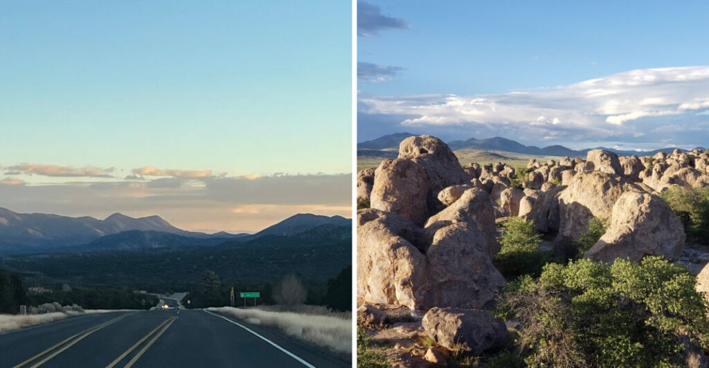
6. City Of Rocks State Park
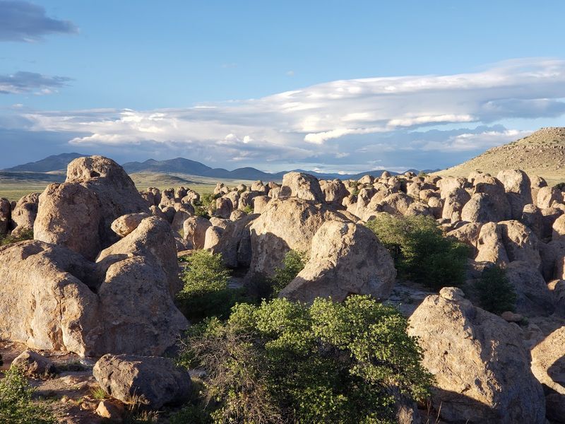
The turn toward 327 Hwy 61, Faywood, NM 88034 feels quiet at first. Then City of Rocks rises from the flat desert floor like you have wandered into a fantasy landscape.
These towering volcanic rock formations, some reaching over 40 feet tall, were created by an ancient volcanic eruption that deposited thick layers of ash which then cooled, cracked, and eroded over millions of years into the boulder maze that visitors wander through today.
The formations are arranged in clusters that create natural corridors, alcoves, and open plazas. That layout is exactly why the park earned its urban-sounding name, despite sitting in the middle of the Chihuahuan Desert.
I spent an entire afternoon just walking the unpaved paths between the rocks, ducking into shaded alcoves, and finding small flat ledges that were clearly designed by the universe specifically for sitting and thinking.
The park has a botanical garden featuring native Chihuahuan Desert plants, which adds an educational layer to the visit that families with curious kids will appreciate.
Camping inside the rock formations is one of the most unique overnight experiences available in the state, with sites nestled between the boulders that feel like sleeping inside a natural fortress.
Stargazing here is extraordinary because the park is located far from major city lights, and its observatory makes the nighttime sky feel like part of the main attraction.
Spring wildflowers sometimes carpet the desert floor between the formations, adding unexpected splashes of yellow and purple to the already dramatic scene.
The drive along Hwy 61 approaching the park cuts through open ranchland with wide desert views that set the mood perfectly before the rocks appear on the horizon.
City of Rocks is the kind of place that makes you feel small in the best possible way, surrounded by ancient geology that has been quietly doing its thing long before any road map existed.
7. Billy The Kid Scenic Byways Visitors Center
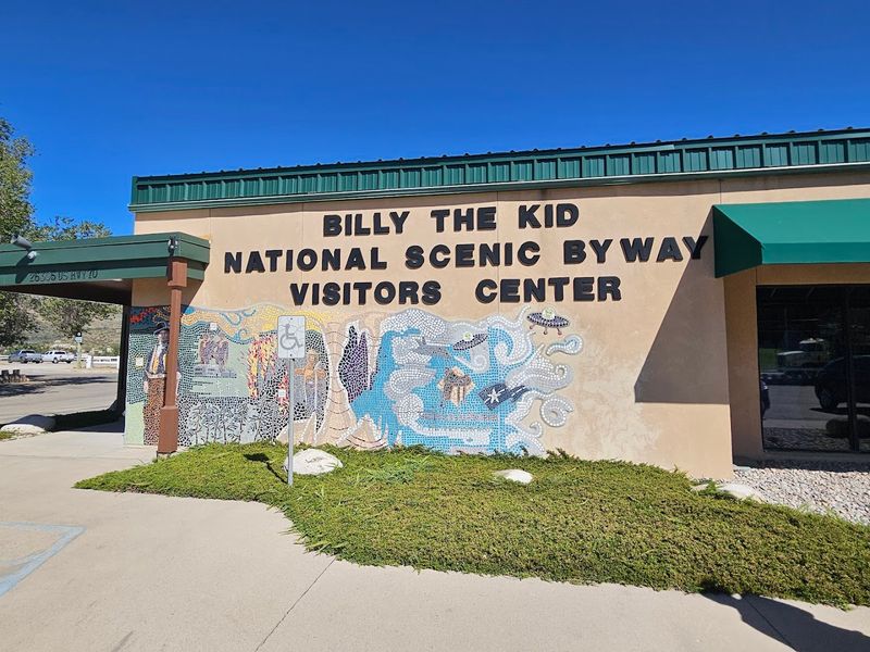
A backroad adventure can start easily at the Billy the Kid Scenic Byway Visitors Center. You will find it at 1461 US-70 West, Ruidoso Downs, NM 88346, near the start of several history-filled routes.
The Billy the Kid National Scenic Byway winds through the Sacramento Mountains and Lincoln County, a region that carries one of the most colorful and storied histories in the American Southwest.
Billy the Kid, the infamous young outlaw of the frontier era, lived and roamed this very landscape, and the towns and trails along the byway still carry echoes of that wild chapter in New Mexico history.
The nearby town of Lincoln is now preserved as Lincoln Historic Site, one of the best-preserved frontier towns in the country, with original adobe buildings lining a single quiet street that has barely changed in over a century.
Ruidoso Downs itself sits at the edge of the Sacramento Mountains near the Mescalero Apache homeland, giving the region a layered cultural identity that goes far deeper than the outlaw legends.
The mountain scenery along the byway is genuinely stunning, with pine-covered ridges, meadow valleys, and the occasional dramatic canyon view rewarding drivers who take their time.
I stopped at the visitors center on a weekday morning and ended up spending nearly an hour looking at the maps, historical exhibits, and trail guides before I even got back in the car.
The center serves as a practical and welcoming gateway to a network of scenic roads that can easily fill two or three days of exploring if you let yourself follow the signs.
Ruidoso itself, just a short drive away, offers great food, art galleries, and mountain trails for anyone who wants to pair their backroad drive with a longer stay in the area.
The Billy the Kid Scenic Byway is where frontier history and mountain scenery shake hands, and the visitors center makes sure you know exactly where to look when they do.